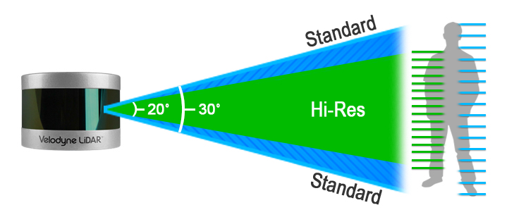
Our response to COVID-19
AUTONOMY & POSITIONING DIVISION

Hexagon's Divisions

Explore Hexagon

Hexagon Agriculture

AGRICULTURE DIVISION

Hexagon Agriculture
Positioning

AUTONOMY & POSITIONING DIVISION

Geospatial

GEOSPATIAL DIVISION

Geosystems

GEOSYSTEMS DIVISION

Hexagon Geosystems
Manufacturing Intelligence

MANUFACTURING INTELLIGENCE DIVISION

Mining

MINING DIVISION

PPM

PPM DIVISION

SI

SAFETY & INFRASTRUCTURE DIVISION

Explore Hexagon

Hexagon_umbrella_Our_Business

OUR BUSINESS


Hexagon_umbrella_Solutions

OUR SOLUTIONS


Hexagon Agriculture

OUR STORY

  • HXGN AS Logo Horizontal Black Darker
  • Products
    • Products by Category
    • Products by Vendor
    • Case Studies
    • Kits
  • Services
    • Integration Services
    • Engineering Services
    • Consulting Services
    • Open Autonomy Pilot
    • Value Added Services
  • Software
    • Highway Automation
    • Shuttle Automation
    • LiDAR Object Processing
    • Speed and Steering Control
  • Platforms
    • Automotive
    • NEV
    • Off-Road
    • Class 8
    • Build Your Own
  • Data Intelligence
    • Data Acquisition
    • Data Laboratory
    • Development & Training
    • Validate & Test
    • Data Calculator
    • Case Studies
    • Simulation Suite
  • Support
  • About
    • Vision, Mission and Values
    • Careers
    • Media
    • News
    • Events
  • Contact
  • Home
  • Products
  • Velodyne Puck Hi-Res

Products

Products by Category Products by Vendor Case Studies Kits

Velodyne Puck Hi-Res

Expanding on Velodyne LIDAR’s groundbreaking VLP-16 Puck Hi-Res, a 16-channel, real-time 3D LIDAR sensor that weighs just 830 grams, Puck Hi-Res is used in applications that require greater resolution in the captured 3D image. Puck Hi-Res retains the Pucks’s 360° horizontal field-of-view (FoV) and 100-meter range, but delivers a 20° vertical FoV for a tighter channel distribution – 1.33° between channels instead of 2.00° – to deliver greater details in the 3D image at longer ranges. This will enable the host system to not only detect but also better discern, objects at these greater distances.

ROS driver available
Fully supported by your AStuff team


Puck Hi-Res Datasheet
Category

LiDAR Products

Learn more about other LiDAR Products

SEE MORE
Brand

More from Velodyne

Learn more about other Velodyne products

SEE MORE

Features

  • 360° Horizontal FOV
  • ± 10° Vertical FoV
  • Dual Returns
  • 16 Channels
  • 100 m Range
  • 300,000 Points per Second
  • Low Power Consumption
  • Protective Design
  • Connectors: RJ45  /  M12

Applications

  • Robotics
  • Automotive
  • Industrial
  • Security
  • UAV
  • Mapping

Media

puck hi res

Downloads

  • Puck Hi-Res Datasheet
  • LiDAR Comparison Chart
  • Velodyne Product Guide
HEXAGON © 2021
  • Cookie Policy
  • Privacy Policy
  • Terms & Conditions
  • Cookie Preferences
  • Sitemap
  • Facebook
  • Twitter
  • Linked In
  • Youtube
  • Instagram